Note
Go to the end to download the full example code.
Precipitation downscaling with RainFARM#
This example script shows how to use the stochastic downscaling method RainFARM available in pysteps.
RainFARM is a downscaling algorithm for rainfall fields developed by Rebora et al. (2006). The method can represent the realistic small-scale variability of the downscaled precipitation field by means of Gaussian random fields.
- Steps:
Read the input precipitation data.
Upscale the precipitation field.
Downscale the field to its original resolution using RainFARM with defaults.
Downscale with smoothing.
Downscale with spectral fusion.
Downscale with smoothing and spectral fusion.
References:
Rebora, N., L. Ferraris, J. von Hardenberg, and A. Provenzale, 2006: RainFARM: Rainfall downscaling by a filtered autoregressive model. J. Hydrometeor., 7, 724–738.
D D’Onofrio, E Palazzi, J von Hardenberg, A Provenzale, and S Calmanti, 2014: Stochastic rainfall downscaling of climate models. J. Hydrometeorol., 15(2):830–843.
import matplotlib.pyplot as plt
import numpy as np
import os
from pprint import pprint
import logging

from pysteps import io, rcparams
from pysteps.utils import aggregate_fields_space, square_domain, to_rainrate
from pysteps.downscaling import rainfarm
from pysteps.visualization import plot_precip_field

# Configure logging
logging.basicConfig(
    level=logging.INFO, format="%(asctime)s - %(levelname)s - %(message)s"
)
Read the input data#
As first step, we need to import the precipitation field that we are going to use in this example.
def read_precipitation_data(file_path):
"""Read and process precipitation data from a file."""
precip, _, metadata = io.import_mch_gif(
file_path, product="AQC", unit="mm", accutime=5.0
)
precip, metadata = to_rainrate(precip, metadata)
precip, metadata = square_domain(precip, metadata, "crop")
return precip, metadata
# Import the example radar composite
root_path = rcparams.data_sources["mch"]["root_path"]
filename = os.path.join(root_path, "20160711", "AQC161932100V_00005.801.gif")
# Read and process data
precip, metadata = read_precipitation_data(filename)
# Nicely print the metadata
pprint(metadata)
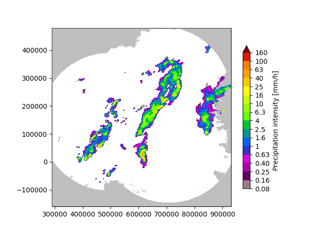
# Plot the original rainfall field
plot_precip_field(precip, geodata=metadata)
plt.title("Original Rainfall Field")
plt.show()
# Assign the fill value to all the Nans
precip[~np.isfinite(precip)] = metadata["zerovalue"]
{'accutime': 5.0,
 'cartesian_unit': 'm',
 'institution': 'MeteoSwiss',
 'orig_domain': (640, 710),
 'product': 'AQC',
 'projection': '+proj=somerc  +lon_0=7.43958333333333 +lat_0=46.9524055555556 '
               '+k_0=1 +x_0=600000 +y_0=200000 +ellps=bessel '
               '+towgs84=674.374,15.056,405.346,0,0,0,0 +units=m +no_defs',
 'square_method': 'crop',
 'threshold': 0.01155375598376629,
 'transform': None,
 'unit': 'mm/h',
 'x1': 290000.0,
 'x2': 930000.0,
 'xpixelsize': 1000.0,
 'y1': -160000.0,
 'y2': 480000.0,
 'yorigin': 'upper',
 'ypixelsize': 1000.0,
 'zerovalue': 0.0,
 'zr_a': 316.0,
 'zr_b': 1.5}
/home/docs/checkouts/readthedocs.org/user_builds/pysteps/envs/latest/lib/python3.11/site-packages/pysteps/visualization/utils.py:439: UserWarning: cartopy package is required for the get_geogrid function but it is not installed. Ignoring geographical information.
  warnings.warn(
Upscale the field#
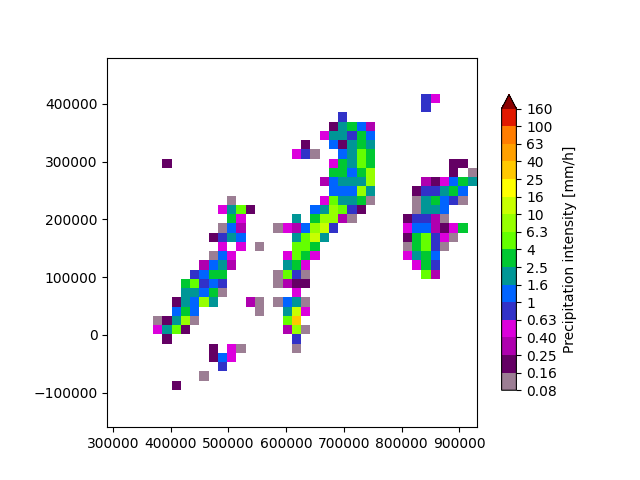
To test our downscaling method, we first need to upscale the original field to a lower resolution. This is only for demo purposes, as we need to artificially create a lower resolution field to apply our downscaling method. We are going to use a factor of 16 x.
def upscale_field(precip, metadata, scale_factor):
    """Upscale the precipitation field by a given scale factor."""
    upscaled_resolution = metadata["xpixelsize"] * scale_factor
    precip_lr, metadata_lr = aggregate_fields_space(
        precip, metadata, upscaled_resolution
    )
    return precip_lr, metadata_lr


scale_factor = 16
precip_lr, metadata_lr = upscale_field(precip, metadata, scale_factor)

# Plot the upscaled rainfall field
plt.figure()
plot_precip_field(precip_lr, geodata=metadata_lr)
plt.title("Upscaled Rainfall Field")
plt.show()
/home/docs/checkouts/readthedocs.org/user_builds/pysteps/envs/latest/lib/python3.11/site-packages/pysteps/visualization/utils.py:439: UserWarning: cartopy package is required for the get_geogrid function but it is not installed. Ignoring geographical information.
  warnings.warn(
Downscale the field#
We can now use RainFARM to downscale the precipitation field.
# Basic downscaling
precip_hr = rainfarm.downscale(precip_lr, ds_factor=scale_factor)

# Plot the downscaled rainfall field
plt.figure()
plot_precip_field(precip_hr, geodata=metadata)
plt.title("Downscaled Rainfall Field")
plt.show()
/home/docs/checkouts/readthedocs.org/user_builds/pysteps/envs/latest/lib/python3.11/site-packages/pysteps/visualization/utils.py:439: UserWarning: cartopy package is required for the get_geogrid function but it is not installed. Ignoring geographical information.
  warnings.warn(
Downscale with smoothing#
Add smoothing with a Gaussian kernel during the downscaling process.
precip_hr_smooth = rainfarm.downscale(
    precip_lr, ds_factor=scale_factor, kernel_type="gaussian"
)

# Plot the downscaled rainfall field with smoothing
plt.figure()
plot_precip_field(precip_hr_smooth, geodata=metadata)
plt.title("Downscaled Rainfall Field with Gaussian Smoothing")
plt.show()

/home/docs/checkouts/readthedocs.org/user_builds/pysteps/envs/latest/lib/python3.11/site-packages/pysteps/visualization/utils.py:439: UserWarning: cartopy package is required for the get_geogrid function but it is not installed. Ignoring geographical information.
  warnings.warn(
Downscale with spectral fusion#
Apply spectral merging as described in D’Onofrio et al. (2014).
precip_hr_fusion = rainfarm.downscale(
    precip_lr, ds_factor=scale_factor, spectral_fusion=True
)

# Plot the downscaled rainfall field with spectral fusion
plt.figure()
plot_precip_field(precip_hr_fusion, geodata=metadata)
plt.title("Downscaled Rainfall Field with Spectral Fusion")
plt.show()

/home/docs/checkouts/readthedocs.org/user_builds/pysteps/envs/latest/lib/python3.11/site-packages/pysteps/visualization/utils.py:439: UserWarning: cartopy package is required for the get_geogrid function but it is not installed. Ignoring geographical information.
  warnings.warn(
Combined Downscale with smoothing and spectral fusion#
Apply both smoothing with a Gaussian kernel and spectral fusion during the downscaling process to observe the combined effect.
precip_hr_combined = rainfarm.downscale(
    precip_lr, ds_factor=scale_factor, kernel_type="gaussian", spectral_fusion=True
)

# Plot the downscaled rainfall field with smoothing and spectral fusion
plt.figure()
plot_precip_field(precip_hr_combined, geodata=metadata)
plt.title("Downscaled Rainfall Field with Gaussian Smoothing and Spectral Fusion")
plt.show()

/home/docs/checkouts/readthedocs.org/user_builds/pysteps/envs/latest/lib/python3.11/site-packages/pysteps/visualization/utils.py:439: UserWarning: cartopy package is required for the get_geogrid function but it is not installed. Ignoring geographical information.
  warnings.warn(
Remarks#
Currently, the pysteps implementation of RainFARM only covers spatial downscaling. That is, it can improve the spatial resolution of a rainfall field. However, unlike the original algorithm from Rebora et al. (2006), it cannot downscale the temporal dimension.
# sphinx_gallery_thumbnail_number = 2
Total running time of the script: (0 minutes 0.796 seconds)